
Exploring Urban Sustainability with Open City Data
For eight weeks in early 2024, twenty students from Harvard University and the Master of Arts in Design Engineering program at Brown University and the Rhode Island School of Design came together as part of the Berkman Klein Center for Internet & Society’s Research Sprint program. As they learned how visualizations of city data can highlight the hidden aspects of urban life, they built interactive data visualizations focused on creating helpful and inspiring experiences for community members as they move through the city of Boston. Their resulting creations were exhibited at Boston’s Museum of Science in April, supporting the public in understanding global sustainability and environmental concerns from a local, city-level perspective. These interactive exhibits, now available online, demonstrate how local vibrancy generates data – from the movements of our neighbors to the ecological changes shaping our landscape.
To create these visualizations, students immersed themselves in the wealth of data available through the city’s public data hub, Analyze Boston. They explored, analyzed, and combined data from a variety of city datasets, including landmark petitions, public transportation routes, shoreline change, tree canopies, Blue Bike trip histories, food truck schedules, farmer's markets, streetlight locations, crime rates, mural locations, and more. As they worked, they received feedback from the city of Boston, the Museum of Science, and other educational and data visualization experts. They also participated in regular sessions with these and other experts from across the globe on data visualization, educational and museum design, surveillance, sustainability, and data use in urban spaces. Together, they considered the tension between using data to improve people’s experiences of cities and minimizing the risks and harms of using city data, even when used for positive purposes.
The Berkman Klein Center is thrilled to be able to share their work. More information can be found on the sprint announcement.
Boston On The Move: A Transportation Adventure Quiz is an interactive quiz that examines and illustrates the metaphorical concept of "access to democracy" in Boston through the lens of urban mobility. This project focused on public service offices in Boston, using them as proxies for democratic engagement. By analyzing how different modes of transportation affect individuals' ability to participate in democratic processes and access public services, the team aimed to shed light on the broader implications of urban mobility on civic participation.
Team
Celine Lee, Master of Public Policy, Harvard Kennedy School ‘25
Charlie Pozniak, Master of Public Policy, Harvard Kennedy School ‘25
Felix Chen, A.B. in Computer Science and Government, Harvard College ‘25
Samyuktha Sam, M.A. in Design Engineering, Brown + RISD '24
Boston Shorelines visualized the evolving contours of Boston’s coastline in response to climate change.
Team
Katie Lynch, M.A.in Design Engineering, Brown + RISD ‘24
Esther Krupp, M.A.in Design Engineering, Brown + RISD ‘24
Max Kwass-Mason, PhD in History of Science, Harvard GSAS
Eva Richter, Master in Public Policy, Harvard Kennedy School
Marking Memory: Boston’s Landmarks in the Making is an interactive map that visualizes and juxtaposes the officially registered landmarks in Boston compared to the grassroots landmarks recognized by local residents. Landmarks serve not merely as physical constructs but as repositories of identity and heritage, embodying the amalgamation of historical narratives, cultural practices, and community values that have been perpetuated across generations. The distinctive distribution of landmarks on the two maps unveils the concealed profundity of certain buildings as the fixed points wherein the collective memory of communities is crystalized and materialized, prompting people to reflect on what it truly means for a place to be considered a landmark and its role in the shaping of public memory.
Team:
Gemma Li, Master in Design Studies, Harvard Graduate School of Design ‘24
Justin Wei, S.M. Data Science, Harvard Faculty of Arts and Sciences ‘25
Kevin Hu, Master in Design Engineering, Harvard SEAS + GSD, 25
Krithika Balaraman, M.A.in Design Engineering, Brown + RISD ‘24
If These Trees Could Talk revealed the secret lives of the city’s trees and their impact on the urban ecosystem Boston is an old city with a rich history, and has been home to countless major events over the centuries. Since the city’s trees have borne witness to these events, they serve as a grounding resource that encourages people to interact with the past. Through the perspective of five different trees in specific Boston neighborhoods and the events (historical and present-day) that they have witnessed, people can explore both the rich stories of and the impact of climate change on Boston. Each story ended with a QR code with links to action items individuals can carry out on their own. The interactive encourages reflection upon on Boston's storied past and highlights the importance of protecting the environment.
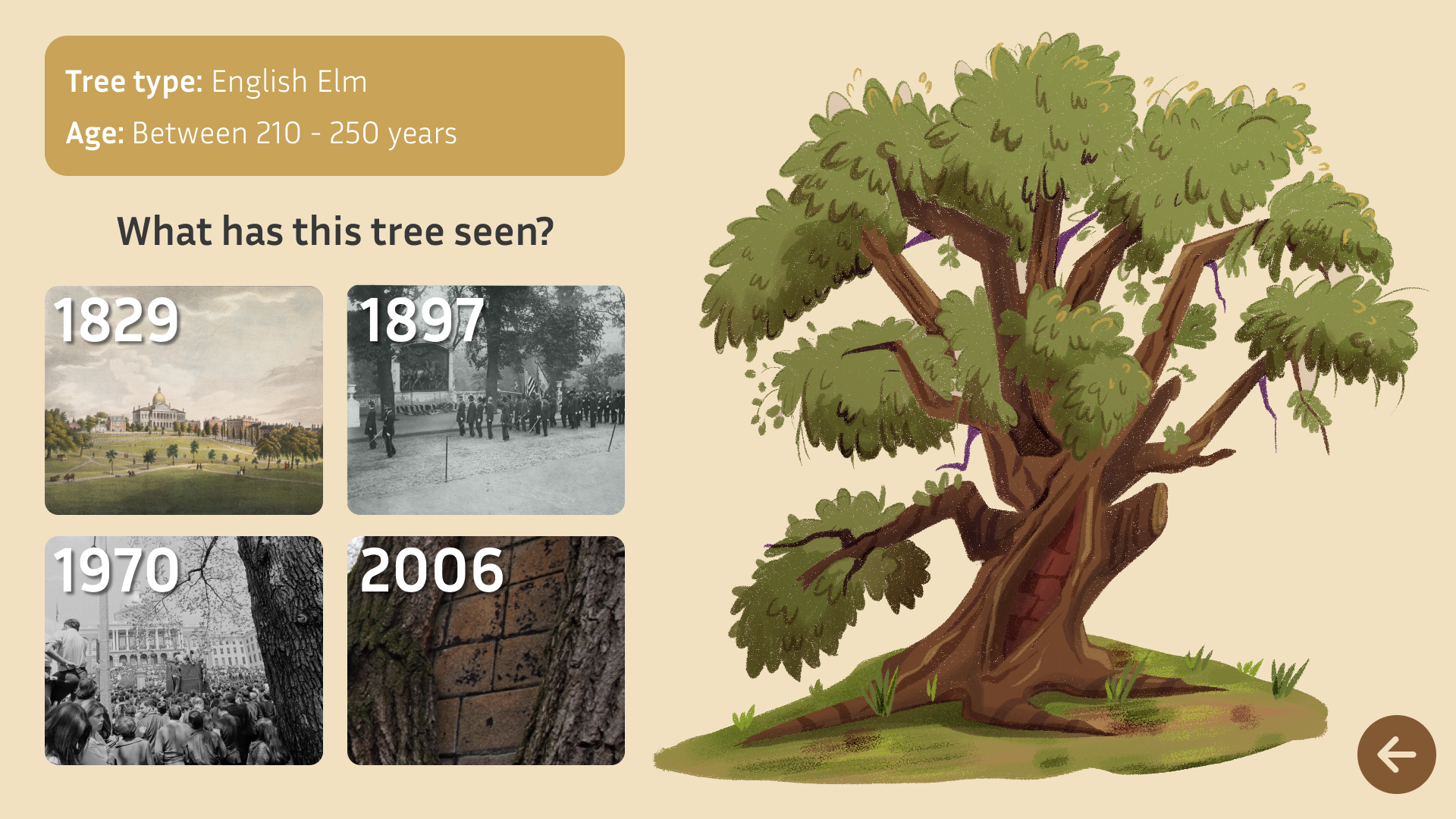
Team:
Chase Van Amburg, A.B. in. Biology and Applied Math, Harvard College ‘24
David James, M.A. in Design Engineering, Brown + RISD ‘24
Jocelyn Shek, A.B. in Sociology and Statistics, Harvard College ‘27
Sunny Satpathy, M.A. in Design Engineering, Brown + RISD ‘24
Why We Gather is an exploration of the characteristics that make excellent gathering spaces in Boston. The interactive is centered on a visualization of key factors that encourage community belonging in eight open spaces in Boston. It shows how much each open space, whether a park, playground, or plaza, demonstrates these factors, specifically art, food, play, and the environment. Why We Gather aims to spark insights about community belonging and wellness and interrogate how individuals, organizations, and governments can play a role in shaping built and natural environments to benefit everyone. The visualizations developed for the selected open spaces can be extended to every open space in Boston and, on a practical level, can help Bostonians and visitors find the spaces that suit their needs.
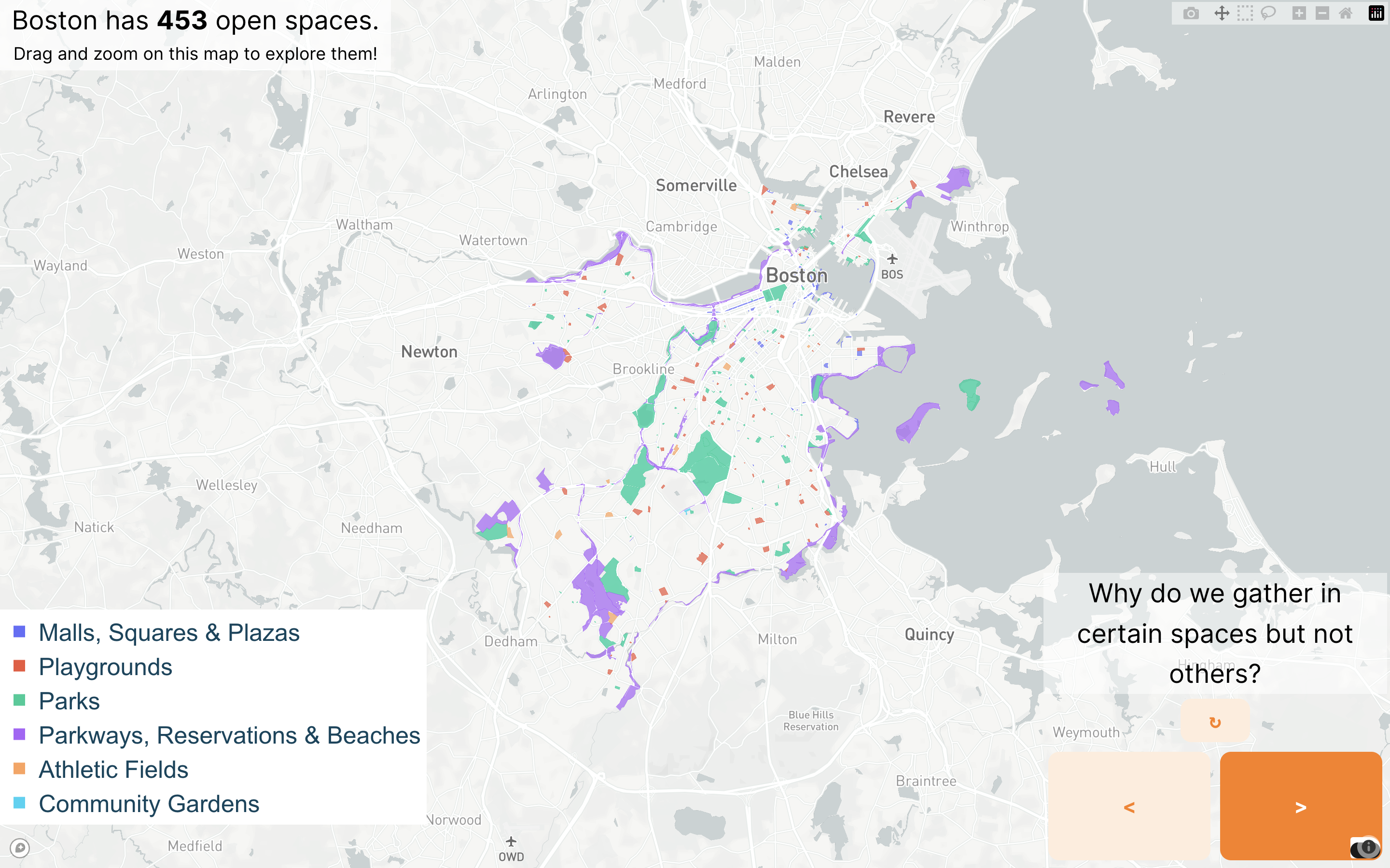
Team:
Conan Lu, A.B. in Computer Science and Philosophy, Harvard College ‘26
Saddat Nazir, A.B. in Neuroscience and Government, Harvard College ‘25
Amy Vu, M.A. in Design Engineering, Brown + RISD ‘24
Henry Wu, A.B. in Statistics and Sociology, Harvard College ‘25
By translating complex data into accessible and engaging visualizations, the projects demonstrate the power of open data and student engagement to enhance public understanding of a community’s many stories. Their projects not only highlight current challenges but, ideally, also inspire action and reflection about how urban environments can be shaped in a human-centered way. We hope that these visualizations will have impact beyond Boston, encouraging cities worldwide to think intentionally and expansively about the role of public data in designing sustainable, ethical, engaged, and delightful community experiences.
The BKC Research Sprint program is an educational initiative that gathers experts and emerging scholars to address current social, ethical, and policy concerns in digital technology.
In the case of this data visualization, a partnership between Berkman Klein Center, Edgelands Institute, and the Master of Arts in Design Engineering program at Brown University and Rhode Island School of Design supported the development of a program and the city of Boston and the Museum of Science.